NMQ: National Mosaic and Multi-Sensor QPE
Comparisons of rainrates from gauges and NMQ
Gauge data
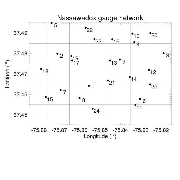
A network of 25 indvidual gauge platforms (two tipping-bucket gauges per platform) was deployed
near Nassawadox, VA area from Apr 2012 to Sep 2013. Now that the
NPOL radar
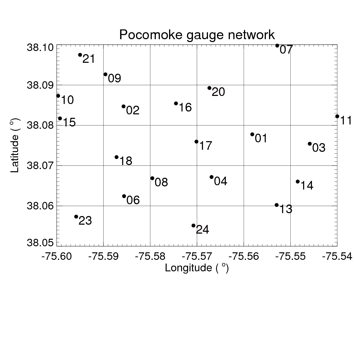
has been deployed in the Newark, MD area, the gauge network has been moved to the Pocomoke area.
Here are two lists of these gauges and their locations as well as their start & end days over Nassawadox
and Pocomoke, respectively. "9999-99-99" denotes the gauge platform is still in the network.
                    Nassawadox, VA

Site      Lon(W)     Lat(N)     FirstDay    LastDay
NASA0001  75.855483  37.464294  2012-06-20  2013-08-20
NASA0002  75.870914  37.479934  2012-05-29  2013-08-02
NASA0003  75.818810  37.480184  2012-06-04  2013-11-01
NASA0004  75.833199  37.485523  2012-04-12  2013-09-19
NASA0005  75.873794  37.494881  2012-05-29  2013-08-02
NASA0006  75.830337  37.457823  2012-04-12  2013-11-05
NASA0007  75.869381  37.462185  2012-04-18  2013-08-01
NASA0008  75.860087  37.458290  2012-06-04  2013-08-20
NASA0009  75.840281  37.477076  2012-05-31  2013-09-18
NASA0010  75.834104  37.489726  2012-04-12  2013-09-18
NASA0011  75.832614  37.454834  2012-04-12  2013-11-05
NASA0012  75.825978  37.472034  2012-04-12  2013-11-04
NASA0013  75.845139  37.476591  2012-04-13  2013-09-16
NASA0014  75.835465  37.468525  2012-04-12  2013-08-20
NASA0015  75.876652  37.458770  2012-04-18  2013-08-01
NASA0016  75.843985  37.486936  2012-04-12  2013-09-20
NASA0017  75.863694  37.476632  2012-04-18  2013-09-19
NASA0018  75.878907  37.472453  2012-05-31  2013-08-02
NASA0019  75.864073  37.478764  2012-04-12  2013-08-01
NASA0020  75.825278  37.489978  2012-04-12  2013-09-20
NASA0021  75.846088  37.466847  2012-04-13  2013-09-16
NASA0022  75.857078  37.492575  2012-04-18  2013-08-02
NASA0023  75.852746  37.487039  2012-05-29  2013-08-01
NASA0024  75.853688  37.453094  2012-06-25  2013-08-20
NASA0025  75.825369  37.464917  2012-04-12  2013-11-04
                    Pocomoke, MD

Site       Lon(W)     Lat(N)     FirstDay    LastDay
NASA0001   75.55817   38.07776   2013-10-18  9999-99-99  Lowes
NASA0002   75.58570   38.08469   2013-08-29  9999-99-99  Mike Sigrist Farm
NASA0003   75.54588   38.07542   2013-12-04  9999-99-99  Harry Williams Site
NASA0004   75.56688   38.06717   2013-10-22  9999-99-99  Pocomoke Middle School
NASA0005   75.56766   38.09393   2013-09-05  2014-06-25  Paul Bashor's house
NASA0005   75.47098   37.93460   2014-07-18  2015-02-05  Pad
NASA0005   75.73399   38.12071   2015-02-05  9999-99-99  SomerseT County Landfill
NASA0006   75.58559   38.06242   2013-12-13  9999-99-99  Glenn Holland
NASA0007   75.55283   38.09977   2013-08-30  9999-99-99  John Gerlach House
NASA0008   75.57955   38.06687   2013-09-03  9999-99-99  Williams Street Well
NASA0009   75.58957   38.09264   2013-09-23  9999-99-99  Hayward's Lott
NASA0010   75.59969   38.08731   2013-10-28  9999-99-99  Josh Lankford Farm
NASA0011   75.54      38.08223   2014-02-04  9999-99-99  Pocomoke City YMCA
NASA0012   75.47098   37.98456   2013-11-01  2014-06-04  Pad159
NASA0012   75.65482   38.36982   2014-06-04  9999-99-99  Dept of Agri.
NASA0013   75.55296   38.06023   2013-10-22  9999-99-99  Pocomoke High School
NASA0014   75.54846   38.06604   2013-09-13  9999-99-99  American Legion
NASA0015   75.59929   38.08171   2013-09-03  9999-99-99  Sysco
NASA0016   75.57449   38.08543   2013-09-26  9999-99-99  Crip Taylor
NASA0017   75.57011   38.07595   2013-10-28  9999-99-99  Pocomoke City Visitor Center Roof
NASA0018   75.58720   38.07211   2013-08-28  9999-99-99  Chip Mill
NASA0019   75.58957   38.08171   2013-09-05  2014-07-14  Atlantic Tractor
NASA0019   75.52278   38.01403   2014-07-21  9999-99-99  Jester site
NASA0020   75.56734   38.08926   2013-09-26  9999-99-99  Somerset road
NASA0021   75.5950    38.09748   2013-09-30  9999-99-99  James East Farm
NASA0022   75.56447   38.05583   2013-09-10  2014-06-03  Fish Plant
NASA0022   75.40291   38.33173   2014-10-16  9999-99-99  Menning Farm
NASA0023   75.57008   38.0640    2013-10-18  2014-02-25  Pocomoke Fairgrounds Island
NASA0023   75.59583   38.05734   2014-03-01  9999-99-99  Herb Kelder Farm
NASA0024   75.57075   38.05513   2013-08-29  9999-99-99  Doc Johnson
NASA0025   75.47101   37.93456   2013-11-04  2013-08-21  N159 Pad
NASA0025   75.34166   38.26268   2014-08-21  9999-99-99  NPOL/D3R after 21 Aug 2014
Comparisons with NMQ at various scales
The following figures show the areal maps of Nassawadox and Pocomoke gauge networks along with 0.01o
NMQ grids. The dots denote locations of the individual gauge platforms with their identification
numbers indicated on the right.
All these gauges measure rainfall in increments of 0.01 inch (0.254 mm).
The gauge tip data are averaged over the entire network,
and compared with the average NMQ rainrates over the same area at hourly, 3-hourly and daily resolutions.
Note:
Gauge data from 21 Sep 2015 to 27 Oct 2015 are missing for most
gauges due to server hack.
Following NMQ data are also missing:
8-15 Sep 2015; 9-10, 23-31 Oct, 2015; 22-23 Nov 2015.
- Cumulative rainfall
- Scatter plot
- Mean difference and relative error
- PDF by occurrence and volume
In the PDF plot, rainrate thresholds are set to 0.1, 0.2 and 0.5 mm/h, which are close to ground radar,
GPM DPR and TRMM PR minimum detectable rainrates.
The inserted "Agreement" in the PDF plot is defined as the fraction of both NMQ and gauge report
the same rain category: rain ( rainrate >threshold), no rain (rainrate <=threshold) among all available
observations.
Agreement=N[(r>T & g>T) + (r<=T & g<=T)] / N(r>=T & g>=T)
where T is rain threshold (0.1,0.2 0r 0.5 mm/h),
N is sample size, r is NMQ rainrate, and g is gauge rainrate.
Be definition, Agreement is between 0 (worst) and 1 (best).
- Daily Rainfall Contour
Also shown below each contour plot are the area-averaged daily rain accumulation and pattern correlation
between NMQ and Gauge Bucket A/B.
Following scatter and PDF plots for combined NSWD & PCMK are after more rigid QCs:
All dates and hours are removed using 4 filters (hhr, day, mean & snow) from Jackson Tan
(Snowdays and their next days are all removed). More rigid QC does not
result in much difference.
- Scatter plot
- PDF by occurrence and volume
|